


ELSI Blog
77 Fogo 2014
Fogo volcano, in the Cape Verde islands [photo 0], returned to active status last Sunday, Nov. 23, 2014. Volcanos erupt regularly, and some rather unexpectedly like Ontakesan in September, with fatal effects. Why muse on Fogo, in particular? Well, I've worked there (I'm a geologist; two of my students did PhD projects in the Cape Verdes), stood at the place now spewing magma, and know the people who monitor the volcano and some who live near the new vent. In short, it's personal.
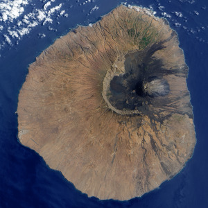
photo 0: Fogo Island from satellite imagery (north is up). Summit caldera (1700 m asl) is floored with black, recent lava flows. Caldera wall (2200 m asl) is circular feature on NW to S sector of summit region against which lavas pond. Highest point on island is resurgent cone, whose small pit crater is the circular feature surrounded by a more grey-colored lava spreading to the east).

Fogo last erupted in 1995. The eruption happened in the summit caldera, a flat plain at 1700 m where two towns -- Portela and Bangueira -- are located. The towns -- surprising in this rather lunar-looking landscape -- exist due to this being a wine growing area. (The vines grow in pits in the volcanic cinders for wind protection and warmth due to the high altitude.) The caldera is difficult to reach from elsewhere on the island. Essentially one road leaves from its south end where the caldera wall is low on account of it being removed in a landslide affecting the whole eastern side of the island about 100,000 years ago.
The present eruption, like the 1995 one, immediately cut the road off, stranding the residents inside the caldera [photo 1] with the vent between the town and the exit route.
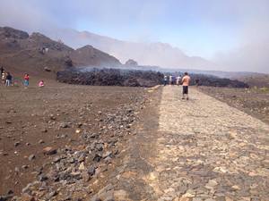
photo 1: Lava flow covering road leading to villages in the caldera.
There is a road to the north out of the caldera, but it only leads to a forested area where firewood is collected and is not linked to the rest of the island's road system. One of the lessons drawn from the 1995 eruption was the need to keep that road maintained and linked with the rest of the island. Sadly, that lesson was not realized in the paving and grading of that north access road.
One lesson was learned, however. There was a somewhat chaotic response to the 1995 eruption because there was no disaster management plan prepared nor lines of communication established during the eruption. International help arrived from Portugal, the UK and the USA and liaising between groups was fraught. After the eruption ended, the Cape Verde government tasked a single agency with the brief of monitoring the volcano and developing a suite of alert levels that would inform government and citizens. This involved training Cape Verde nationals in the skills required and embedding them in the monitoring agencies. Though there were some bumps on the way to achieving this, eventually a monitoring network emerged and communication paths established between civil protection authorities and the monitoring network. A real-time seismic monitoring network now runs to monitor the islands most likely to threaten Cape Verdeans with eruptions: Fogo and Santo Antao. The Fogo network recorded increased seismicity through the month of August, rising towards the base of Fogo island. At about 4 km depth the seismicity stopped, and volcanic tremor started. At this point an alert was declared (the evening before the start of the eruption), triggering the disaster mitigation plan.
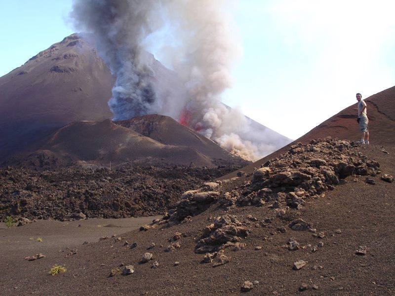
The eruption began around 23:00 GMT on 23 Nov. It fortunately, was, and remains, a relatively mild type, strombolian or hawaiian. There is fire fountaining and minor ash venting (ash is powdered lava), gas emission (carbon dioxide and sulfur dioxide), but no major explosive activity (as of 30 Nov.)

photo 2: Picture of eruption focus. Two vents are visible. The leftmost one is emitting bluish-colored ash. The rightmost one is fire fountaining; the red glow is lava thrown into the air. The fountaining is driven by gas emission, shown by the white vapor. The eruption is not particularly explosive. Flowing lava is on flat between foreground hill and vents.
So, the residents were able to evacuate by giving the vent a wide berth, climbing across the lava field from the 1995 eruption with their posessions in their arms, and convoying their goods down the main access road past the point of disruption by the lava. As of 28 Nov., everybody from the towns was evacuated.
However, one lava flow is heading straight for the towns [photo 3]. It already destroyed 15 houses and an administrative building. The flow front is about 50 m from the town's school. Further effusion along this path will destroy the town's center, making resettlement difficult. On-site reports on 29 Nov. say that lava flow rates are increasing, so the outlook is not good. This eruption is more cruel than 1995's.
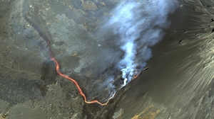
photo 3: Satellite image showing vent and flow heading northwards towards Portela. Village buildings visible in upper left of photo.

Teams of volcanologists and geophysicists from universities in Lisbon (U. Lisbon and IST) are converging on Fogo to help with monitoring the ongoing eruption. Fortunately, due to preparedness plans by the government, no lives were lost and the evacuation proceeded in an orderly fashion with minimal loss of property. If the 1995 eruption is a guide, this eruption will also last for perhaps two months. The difficult part of managing the event is still to come. Once people become used to the eruption's characteristics they will increasingly want access to the caldera -- their livelihood source -- and finding the balance between safety and access will not be easy.